

President: Isaias Afwerki
Capital: Asmara
Land area: 121 320 Kilometres squared
Population: 6,086,495. Growth rate: 2.42%, birth rate: 32.1/1000, infant motarlity: 40.34/1000, life expectancy: 62.86
Monetary unit: Nakfa
Languages: Afar, Arabic, Tigre, Tigrinya and Kunama.
Ethnicity: Tigrinya: 50%, Tigre and Kunama: 40%, Afar: 4%, Saho: 3% and other: 3%
Literacy rate: 58.2%
Economic summary: GDP/PPP $3.978 billion, Inflation: 20%, unemployment: 12.1%, real growth rate: 8.2%. Countries like Germany, China and Brazil make up some the major traders with this country
Agriculture: Production of sorghum, lentils, vegetables, corn and cotton is rive. Existence of natural resources like gold, zinc, copper, salt and possibly oil drive the suffering economy in this country.
Geography
Eritrea was formerly the northernmost province of Ethiopia and is about the size of Indiana. Much of the country is mountainous. Its narrow Red Sea coastal plain is one of the hottest and driest places in Africa. Eritrea is bordered by the Sudan on the north and west, the Red Sea on the north and east, and Ethiopia and Djibouti on the south.
History
Eritrea was part of the first Ethiopian kingdom of Aksum until its decline in the 8th century. It came under the control of the Ottoman Empire in the 16th century, and later of the Egyptians. The Italians captured the coastal areas in 1885, and the Treaty of Uccialli (May 2, 1889) gave Italy sovereignty over part of Eritrea. The Italians named their colony after the Roman name for the Red Sea, Mare Erythraeum, and ruled there until World War II. The British captured Eritrea in 1941 and later administered it as a UN Trust Territory until it became federated with Ethiopia on Sept. 15, 1952. Eritrea was made an Ethiopian province on Nov. 14, 1962. A civil war broke out against the Ethiopian government, led by rebel groups who opposed the union and wanted independence for Eritrea.
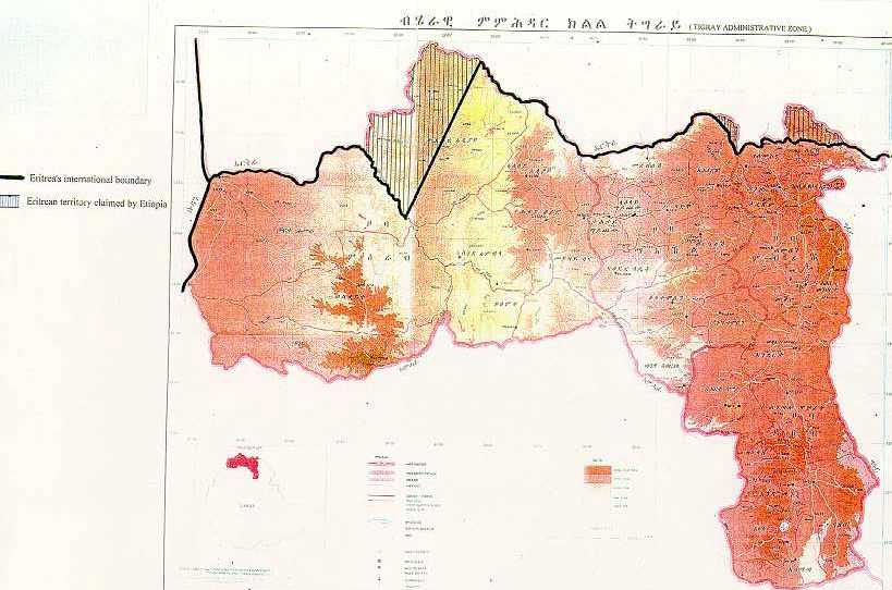
Following Eritrea's independence in 1993, a boundary commission had been established to cover the Yirga Triangle (Badme) and other disputed areas. In 1997, the Ethiopian authorities issued a map of the Tigrayan Administrative Region which confirmed Tigrayan expansionism. The map proved to be the end of the good relations between Eritrea and Ethiopia, and resulted in an armed conflict in August 1997 and an all-out war in May 2000, when Ethiopia occupied large parts of Eritrea. An estimated 1.1 million Eritreans have been displaced by Ethiopian aggression and an estimated 100.000 Ethiopian and 20.000 Eritrean soldiers were killed in this two year war.
On June 19th 2000 both parties agreed on a ceasefire and on December 12th 2000 a peace agreement was signed in Algiers. A 4200-strong multinational UN peacekeeping force (UNMEE) was deployed for the de-mining and demarcation of the border.
On April 13th 2002 the Permanent Court of Arbitration in The Hague published the conclusions of the Eritrea-Ethiopia Boundary Commission. The lands bordering the Yirga Triangle, areas, including Badme in the Central zone and Eastern Sector and border town Tserona have been awarded to Eritrea. The border towns Zalambessa and Alitena (Central Sector) and Bure (Danakil Depression) were awarded to Ethiopia.
Economy
Eritrea has faced many economic problems, including lack of resources and chronic drought, which have been exacerbated by restrictive economic policies. Eritrea has a command economy under the control of the sole political party, the People's Front for Democracy and Justice (PFDJ). Like the economies of many African nations, a large share of the population - nearly 80% - is engaged in subsistence agriculture, but the sector only produces a small share of the country's total output. Since the conclusion of the Ethiopian-Eritrea war in 2000, the government has expanded use of military and party-owned businesses to complete President ISAIAS's development agenda.
The government has strictly controlled the use of foreign currency by limiting access and availability; new regulations in 2013 have slightly relaxed currently controls. Few large private enterprises exist in Eritrea and most operate in conjunction with government partners, including a number of large international mining ventures that have recently begun production. While reliable statistics on food security are difficult to obtain, erratic rainfall and the percentage of the labour force tied up in national service continue to interfere with agricultural production and economic development.
Eritrea's harvests generally cannot meet the food needs of the country without supplemental grain purchases. Copper, potash, and gold production is likely to drive economic growth over the next few years, but military spending will continue to compete with development and investment plans. Eritrea's economic future will depend on market reform, international sanctions, global food prices, and success at addressing social problems such as illiteracy and low skills.
Tourism
Destinations like the ASMARA a city above the clouds. With a perfect climate, remarkable architecture, spotless and safe streets, Asmara ranks among the most pleasant and remarkable capitals on the African continent and in the world. Asmara stands alone as the only capital, other than Cairo, that is founded on the ruins of culture that gave birth to contemporary life; as such it resembles other capitals that boast great antiquity, such as Rome or Athens. It traces back its origin to 800BC with a population ranging from 100 to 1000 people.
MASSAWA – The Pearl of the Red Sea: A city which for centuries has been one of the region’s most important ports, a city whose charm has been influenced over the past centuries by the Portuguese, the Arabs, the Turks, the Egyptian, the British, the Italians and, most of all, the Eritreans themselves. Situated on the Red Sea Coast, 115 Kilometres away from Asmara, Massawa is one of the oldest and most historic cities of Eritrea. Known to have been inhabited by Muslims in the 10th century AD, it fell under the Turkish domination in the 16th century.


